



Context and objectives
Extreme climate events, particularly flash floods and runoff-driven flooding, severely disrupt urban transport networks and compromise crisis management. These disturbances are not limited to physical infrastructure: they generate cascading effects, notably through the degradation of telecommunication networks, which affect the coordination of relief efforts and access to information.
Despite advances in the modelling of hydrological hazards, of mobility, and of digital networks, these dimensions are today still largely studied in isolation. The result is a lack of integrated tools capable of anticipating, simulating, and steering operational responses in critical situations, particularly in the first minutes to hours following an event.
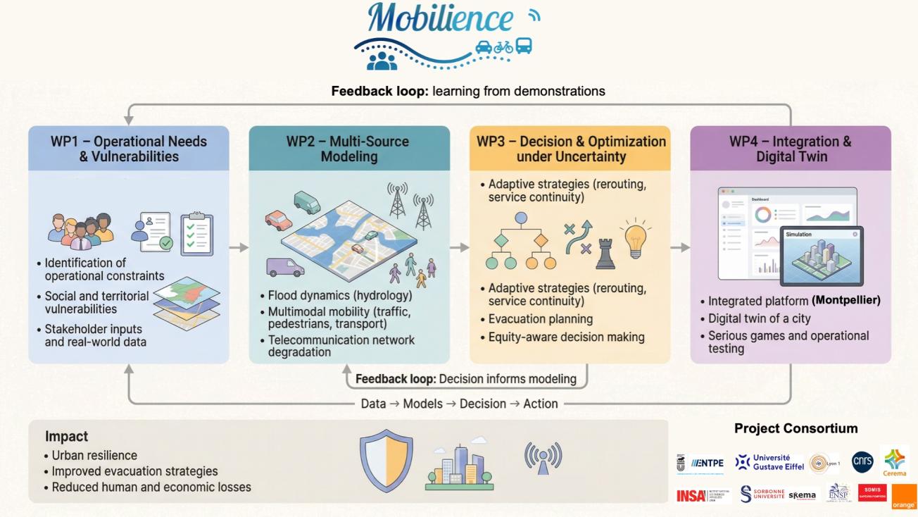
The MOBILIENCE project aims to fill this gap by developing an integrated approach based on the data–models–decision continuum, in order to strengthen the resilience of urban mobility systems in the face of disturbances of varying intensity. The main objective is the design of a digital platform capable of dynamically simulating the interactions between flooding, multimodal mobility, and telecommunication infrastructure, while accounting for uncertainties, individual behaviours, and socio-territorial vulnerabilities.
The project focuses in particular on the critical window following the onset of an event, when decisions must be rapid and robust. It aims to provide decision-support tools that make it possible to maintain services, reorganise mobility flows, or plan evacuations, while integrating objectives of equity and of protection for vulnerable populations. Finally, MOBILIENCE is embedded in a strongly operational approach, resting on co-construction with field stakeholders and the implementation of an urban digital-twin prototype, demonstrated on the case of the Montpellier metropolitan area.
Expected outcomes
MOBILIENCE will produce a coherent set of scientific, technological, and operational results aimed at transforming the way flood-related crises are anticipated and managed in urban environments.
The main deliverable will be an integrated digital platform for simulating the coupled dynamics between flooding, multimodal mobility, and telecommunication networks. This platform will rest on the integration of multi-scale, multi-source models, combining empirical data, physical simulations, and artificial-intelligence approaches to generate realistic scenarios, including for rare or extreme events.
On the decision-making level, the project will develop optimisation methods under uncertainty capable of proposing strategies suited to different levels of disturbance: service continuity for localised incidents, dynamic reconfiguration of networks in the event of major disruptions, and evacuation planning in critical situations. These approaches will explicitly integrate social and territorial vulnerabilities, via dedicated indicators such as the loss of accessibility for populations.
The project will also produce a digital-twin prototype of the Montpellier metropolitan area, used as an operational demonstrator. This twin will make it possible to organise simulation exercises and serious games involving crisis-management stakeholders, in order to test and validate the proposed strategies under realistic conditions.
Beyond the tools, MOBILIENCE will generate open resources compliant with the FAIR principles: datasets, scenario libraries, reproducible code, and educational materials. These results will aim to facilitate transfer to local authorities, State services, and operators, thereby contributing to better crisis preparedness and to a reduction in human and economic impacts.
Project organization
Project leader
Angelo Furno (ENTPE), Senior Research Scientist at the ENTPE, expert in the analysis and understanding of urban mobility dynamics from large-scale, multi-source data
Angelo Furno is a Senior Research Scientist (directeur de recherche) at the ENTPE and a member of the EMob-Lab laboratory (ENTPE / Université Gustave Eiffel).
His work lies at the interface between data science, complex-systems modelling, and transport engineering, with a focus on the analysis and understanding of urban mobility dynamics from large-scale, multi-source data (mobile telephony, sensors, operational data).
He develops approaches combining artificial intelligence, physical modelling, and optimisation to strengthen the resilience and efficiency of critical infrastructure, particularly in disrupted or uncertain contexts.
He coordinates and participates in several national and international projects aimed at bridging the gap between academic modelling and operational needs, by producing decision-support tools for complex urban systems.
The scientific leadership of the project will be shared with Alexandre Nicolas, Research Scientist (HDR) at the CNRS, affiliated with the Institut Lumière Matière (Univ. Lyon 1 and CNRS).
His work addresses the physical, multi-scale modelling of mobility, notably pedestrian dynamics and traffic flows, drawing on approaches from statistical physics and complex systems.
He develops models with strong explanatory power, empirically validated, that make it possible to better understand collective behaviours in both normal and disrupted situations.
Partners