
Context and objectives
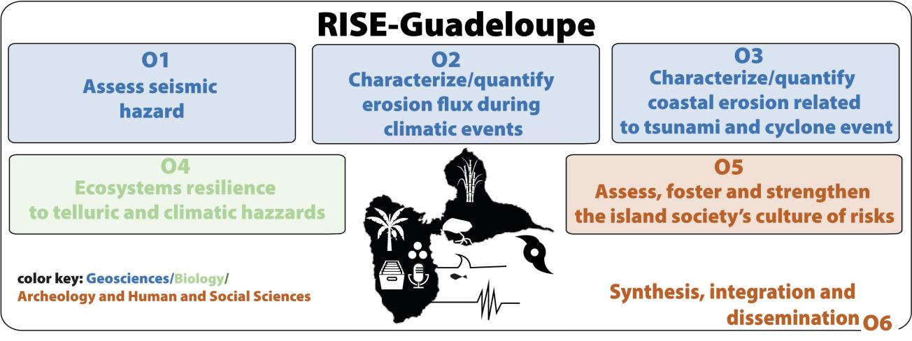
Located within an active subduction zone, Guadeloupe is subject to a combination of geophysical hazards (earthquakes, tsunamis), climatic hazards (cyclones, extreme precipitation), and environmental hazards (erosion, ecosystem degradation), whose interactions remain insufficiently understood. One of the project's central aims is therefore to move beyond sectoral approaches and to offer an integrated analysis of the physical, biological, and social processes that govern these risks.
With this in mind, RISE-Guadeloupe seeks to better characterise hazards across different temporal and spatial scales, notably by reconstructing the history of extreme events from natural and historical archives, and by improving models for forecasting phenomena such as tsunamis, sediment flows, and coastal erosion.
The project also aims to quantify the impacts of these hazards on terrestrial and marine ecosystems, as well as on human societies, drawing on approaches from the geosciences, ecology, archaeology, and the social sciences. A further key objective is to strengthen risk culture and the resilience capacities of island societies, by analysing historical adaptation dynamics and contemporary risk perceptions. To this end, the project relies on participatory approaches and outreach initiatives designed to foster dialogue between scientists, decision-makers, and local populations.
Finally, RISE-Guadeloupe seeks to establish an interdisciplinary research framework grounded in the sharing and integration of data, in order to produce robust knowledge that is transferable to other island territories exposed to similar hazards, particularly in subduction zones worldwide.
Expected outcomes
RISE-Guadeloupe will deliver major scientific, methodological, and operational outcomes, with the central aim of translating them into concrete decision-support tools, notably in the form of thematic maps intended for risk-management stakeholders. It will significantly advance knowledge of geophysical hazards through the creation of an integrated database of active faults and the reconstruction of the history of earthquakes and tsunamis, leading to the production of active-fault, seismic-hazard, and tsunami-inundation maps that can be used directly by the authorities.
The project will also bring significant advances in characterising erosion processes and sediment flows under extreme conditions. Field observations, instrumented measurements, and the models developed will make it possible to produce flood-hazard, sediment-transport, and coastal-erosion maps that are essential for spatial planning and crisis management. These approaches will allow a better quantification of the interactions between catchments, coastal zones, and marine environments, and will translate this knowledge into spatially explicit representations that can be directly mobilised.
In parallel, RISE-Guadeloupe will document the impacts of hazards on terrestrial and marine ecosystems, producing maps of the vulnerability and resilience of natural environments that will support environmental planning and the protection of sensitive areas. On the societal level, the project will contribute to a better understanding of risk culture and adaptation dynamics, making it possible to develop maps of social vulnerability and exposure that integrate historical, cultural, and territorial dimensions.
Finally, all of these data and models will be integrated into visualisation and sharing tools, in order to provide decision-makers, crisis managers, and local stakeholders with synthetic, legible, and operational resources. These deliverables will constitute a reference framework transferable to other island territories exposed to multiple hazards, strengthening the project's impact in terms of prevention, anticipation, and risk management.
Project organization
Project leader
Mélody Philippon (CNRS), geoscientist specialising in structural geology and tectonics
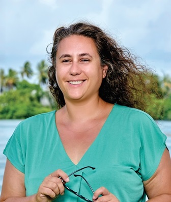
Mélody Philippon
Mélody Philippon
Mélody Philippon is a geoscientist specialising in structural geology and tectonics. She completed her doctoral thesis at Géosciences Rennes (2010), where she focused on the restoration of long-term crustal deformation, combining structural analysis, field observations, and analogue modelling in order to reconstruct the geodynamic evolution of the Hellenides.
Her work helped to better constrain the deformation processes at play during the burial and exhumation of high-pressure rocks. She continued her career with postdoctoral positions at Utrecht Universiteit (Netherlands) and at the CNR in Florence (Italy) (2011–2012), where she studied extensional margins and the interactions between long-term deformation and recent tectonic activity along the East African Rift in Ethiopia. Throughout her career she has developed expertise in the integrated analysis of crustal deformation. These international experiences reinforced her command of integrated approaches, combining geological, geochronological, geochemical, geophysical, and geomorphological data.
Since her appointment at the Université des Antilles (2014), her work on regional tectonics has advanced understanding of the last forty million years of the regional evolution of the eastern Caribbean plate. In this context, she has led the scientific coordination of the ANR SUBUTTEC project since 2024, a multidisciplinary project exploring the relationships between palaeogeographic evolution and the molecular clocks of endemic species of the eastern Caribbean, consolidating her experience in leading collaborative and interdisciplinary projects.
For several years she has been developing collaborations with seismotectonicists, neotectonicists, and tsunami modellers (seismic source) in order to link long-term processes with recent tectonic activity and the associated risks (involvement in the Active Fault France network, FACT, with the creation of a Region No. 10, the Antilles).
She is now scientific coordinator of the PEPR project RISE-Guadeloupe (PEPR: Programme et Équipement Prioritaire de Recherche, a priority research programme and facility funded under France 2030), through which she has brought together a multidisciplinary scientific community around the challenge of developing an integrated approach to natural hazards, their cascading effects, and their impacts. The RISE-Guadeloupe project aims to produce operational deliverables for decision-makers and crisis managers, notably maps of active faults, seismic and tsunami hazard, flooding, coastal erosion, and vulnerability, underpinned by integrated models and harmonised databases. RISE-Guadeloupe is part of a wider effort to strengthen the link between fundamental research and societal challenges, particularly in the prevention of risks and the adaptation of exposed territories.
Partners